A Study on Application of Discrete Vortex Method
to Coastal Circulation
by
Keita FURUKAWA*
INTRODUCTION
To
implement environmental measures in enclosed inner bay, modeling tools for
macro and micro scale environmental impact assessment are required. A discrete vortex method can be an
effective method to simulate multi scale flow such as eddies behind island,
headlands and narrow channel at inlet of a bay. Nevertheless, a discrete vortex method
has been developed as one of direct simulation methods for Navier-Stokes
equation. The method should be extended
to facilitate 3-D effects of shallow coastal water and modeling of several
hundred meters to kilo meters sized scale (meso-scale) eddy in a bay. Firstly, the model parameter fitted for
small scale (several centi-meters to meter) flow. Secondly, the model was modified to
simulate meso-scale coastal circulation.
FORUMURATION OF DISCRETE VORTEX METHOD
A
viscous vortices model is introduced for reduction of a calculation time and
simplification of the model. The
vortices model is expressed as;

(1)
where, ![]() is distance from
center of vortices,
is distance from
center of vortices, ![]() is tangential
velocity,
is tangential
velocity, ![]() is total
circulation of represented vortices,
is total
circulation of represented vortices, ![]() is diffusion
scale parameter that has same dimension of a diffusion coefficient, and
is diffusion
scale parameter that has same dimension of a diffusion coefficient, and ![]() is elapsed time
after the vortices released into the flow field. Way of parameter fitting and modification
of the method are presented at following section.
is elapsed time
after the vortices released into the flow field. Way of parameter fitting and modification
of the method are presented at following section.
MODEL EXAMINATION BY BASIC HYDRAULIC
MODEL TEST
Discrete
vortex method’s parameters were tuned for small scale basic hydraulic model
test such as a wake formulation behind an inclined flat plate (Figure 1). These parameters are formulated by
Reynolds number using far field flow velocity as velocity scale and plate size
as scale length.
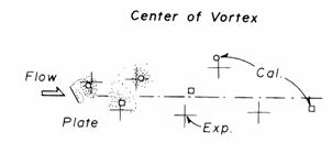
Figure 1: One of test case for tuning of discrete vortex
method.
The
second case is wake generation by series of steps on a wall. The most upstream step generate eddies
that transported to downstream. If
the eddies interact with successive eddies generated from second – third steps is
tested by numerical model tests using the discrete vortex method. Boundaries can be set by simple sequence
of boundary vortices put on the boundary surface.
Velocity
attenuation process due to multi objects set on flow field is studied as third
case. Simulated wakes from objects are
interacted each other, and makes patchy pattern of water retardant area and accelerated
jet flow area. By detail velocity information,
it is enables to determine total drag force acting on objects.
MODEL ALTERNATION FOR
SIMULATE COASTAL CIRCULATION
The
discrete vortex model is based on 2-D Navier-Stokes equation. Thus, only two dimensional effects are modeled. Furthermore, parameter fitting based on
Reynolds number gives too small time step to solve large scale phenomenon. The model was altered to use in
meso-scale (100m-10km) coastal circulation.
Bottom
frictional effects are separately modeled, and additional terms are added in
advection terms of vortex transport equation. The model parameters were adjusted by
using diffusion scale. The extended
vortex discrete method successfully models asymmetry wake circulation behind
The
extended method also checked to model jet flow generated by small channel
between island and mouth of bay (Figure
3). The discrete vortex method
show equivalent performance to full 3-D model code.
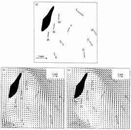
Figure 2: Wake behind
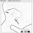
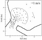
Figure 3: Flow around a channel between Palm islands. Left) observed current pattern at flood
tide by VHF radar. Right)
calculated current pattern by discrete vortex method.
CONCLUSION
The
discrete vortex method presented by this paper shows time efficient and high accuracy
performance to calculate coastal circulation such as wake, eddy street, and
vortex shedding. Tested range of
Reynolds number is 1000 – 80000.
The
method is extended to simulate coastal circulation but restricted for semi-3D
calculation (barotropic flow). It
is big restriction of using the method.
Nevertheless, if the user understand advantage and disadvantage of the
method, the discrete vortex method can be a powerful tool to assess coastal
circulation.
* (National Institute for
Land and Infrastructure Management)